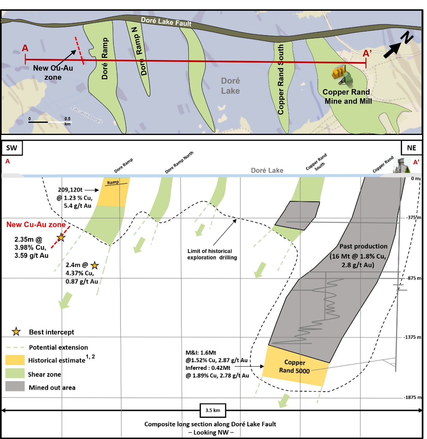
The Doré Ramp gold-copper deposit is located approximately 2.5 km by road of the Copper Rand mill.
In 2022-23, the Company completed six holes, including two wedge cuts, for a total of 7,020 meters. The first hole of the program (LDR-22-01), completed in 2022, intersected the Doré Ramp mineralized zone approximately 350 meters down plunge from the deepest historical drill hole and returned an intercept of 2.4 meters grading 4.37% Cu, 0.87 g/t Au and 13.0 g/t Ag, including 0.5 meters grading 17.6% Cu and 1.76 g/t Au.
A new copper-gold mineralized zone was intersected in all six holes over a strike length of approximately 360 meters. It is located approximately 300 meters to the south of the Doré Ramp zone with parallel strike and dipping approximately 55° to the southwest as per current interpretation. The new zone is characterized by a 2 to 8 meter zone of quartz veining containing localized disseminated and/or massive chalcopyrite and pyrite within a large ductile fault zone that is strongly sericitized and chloritized. The best results for this new zone included:
Note: The true width of the structures intersected is estimated at approximately 80% of the downhole width.
The Doré Ramp deposit (previously called Lac Doré Ramp) is within the Chibougamau Central mining camp and as many other deposits and mineral occurrences it is within a wide (from 100 to 400 meters) shear zone perpendicular to the Lac Doré fault. In the Chibougamau Central camp, the copper and gold-rich mineralized zones are in contact with acidic to intermediate dykes interpreted as coming from the Chibougamau Pluton. The Doré Ramp deposit starts at 80 meters below surface and has been tested over a strike length of approximately 500 metres. It consists of a series of subparallel pinch and swell veins, varying in thickness from 0.3 to 7.7 meters, that extend from 150 to 300 meters along strike. A number of mineralized lenses are displaced by northeast faults at 15 to 30 metres intervals.
The Doré Ramp deposit was drilled in a few different phases from 1984 to 1992 with a total of 47 drill holes from surface. A double ramp approximately 1 kilometer long was excavated in 1991-92 to a vertical depth of 160 meters, followed by an underground drilling campaign of 46 holes totaling 10,200 meters testing the deposit to a depth of 240 meters. Only five holes tested the deposit between 300 and 600 meters. At the end of 1992, Westminer Canada reported a historical estimate of 209,120 tonnes at 1.23% Cu and 5.4 g/t Au, from a depth of the surface pillar of 115 meters to 350 meters1 (Source: Westminer Canada Limitée, Project Lac Dore, November 1992). No subsequent exploration programs were carried out on the Doré Ramp deposit.
1. This estimate is considered to be historical in nature and should not be relied upon. A Qualified Person has not completed sufficient work to classify the historical estimate as a current mineral resource or mineral reserve. The Company is not treating the historical estimate as current mineral resources or mineral reserves).