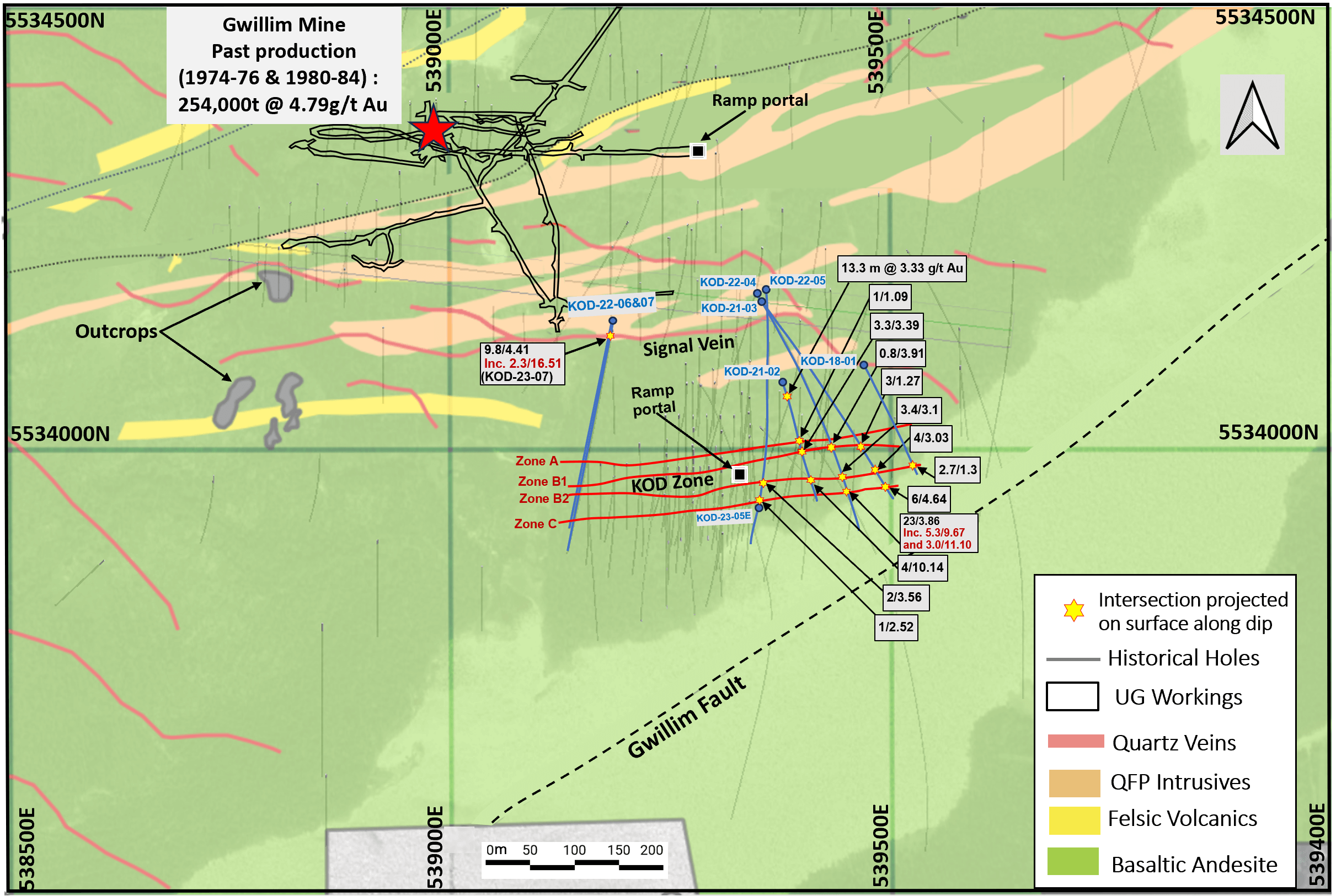
The Gwillim property totals 486 ha and is located 8 km by road northwest of Chibougamau. The western part of the property (385 ha) is under a 50/50 joint venture between Dore Copper and Argonaut Gold Inc. (through its wholly owned subsidiary Prodigy Gold Inc.) with Dore Copper being the operator. The eastern part of the property (102 ha) is 100% owned by Dore Copper. Located on the joint venture land, the Gwillim mine operated between 1974 and 1976 and again from 1980 to 1984. In total 245,066 short tons were mined at a grade of 4.79 g/t Au1. Most of the production came from the Main zone, which extended along strike for 122 m with an average width of 2.6 m and up to a depth of 114 m.
In 1987, two high-grade intercepts of 7.6 m at 38.0 g/t Au and 7.9 m at 17.9 g/t Au were drilled by Greenstone Resources at moderate depths of 200 to 300 m at the KOD zone (300 m south of the mined Gwillim Main zone)2. A further 25 holes were drilled from the surface before a ramp was developed and the zone was further explored from underground in 1988 but not mined (some development through ore). In 1989, three more surface holes were drilled to depths of 400 m with one hole confirming the extension of the high-grade mineralization beyond 300 m vertical depth. No other significant exploration activities are reported after this work.
From 2018 to 2023, the JV has completed six drill holes totaling 3,321 meters targeting the KOD Zone and intersecting the Signal Zone. Best intercepts included*:
*Refer to news releases dated April 21, 2022, May 29, 2023, and October 17, 2023.
Gwillim is hosted within the Bruneau Formation in pillowed basalts and gabbroic sill. Mineralization, as described at the Gwillim mine, is hosted predominantly within east-west, steeply dipping structures containing quartz-carbonate veins with limited amounts of massive sulphides.
KOD Zones
At KOD, there are four main parallel east-west mineralized zones, each less than 50 m apart (Zones A, B1, B2 and C). The thickness of the mineralization varies from 0.3 m to 8.0 m. Gold mineralization in the KOD zone is found mainly in millimetric to centimetric quartz veins intersecting the massive basalt unit close to the contact with gabbroic or quartz-feldspar (“QFP”) dykes, which range from 30 cm to 10 m. In some places, especially along Zone C, these veins can take the expression of silica flooding in basaltic pillow rims, associated with pyrite, pyrrhotite and chalcopyrite. Visible gold is occasionally observed. The KOD mineralized system remains open along strike to the east and below 600 m.
Signal Zone
The Signal Zone has been historically traced over a strike length of 600 m and is approximately 170 m north of the KOD Zone A. In the late 1980s, approximately 2,357 m in 27 holes tested the Signal Zone. In addition, a number of historical holes were drilled from underground intercepting both the Signal and KOD Zones.The best historical gold intersections from the surface program (see reference 3) included: 7.1 g/t Au over 2.6 m (SZ-87-6), 34.96 g/t Au over 1.37 m (SZ-87-10), and 22.9 g/t Au over 1.2 m (GL-41). The Signal zone for its part remains open below 230 m. A compilation of this historical work from the Signal Zone is currently underway.
References: