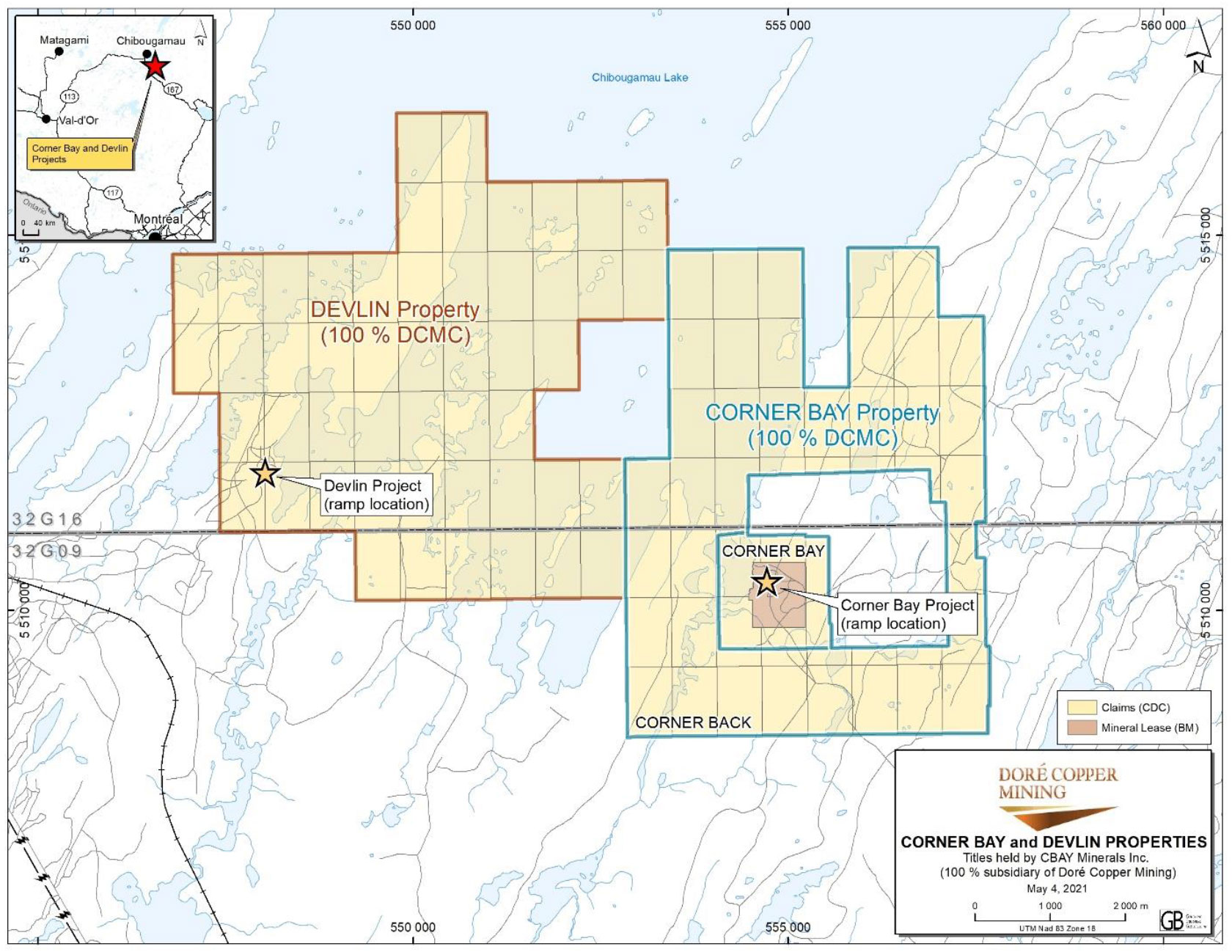
| Location | 18 km south of Chibougamau, QC |
| Ownership | 100% Dore Copper |
| History | 1981 access decline to 55 m below surface; bulk sample of ~2,700 short tons averaging 1.26% Cu processed |
| Commodities | Copper and gold |
| Current Status | Starting Feasibility Study |
| Mineral Resources (2022) | Measured & Indicated: 0.77 Mt @ 2.17% Cu and 0.20 g/t Au Inferred: 0.48 Mt @ 1.79% Cu and 0.17 g/t Au |
The Devlin project is an easily accessible, partially developed, high-grade copper deposit located approximately 10 kilometres west of Corner Bay and 35 kilometres by road from the Copper Rand mill.
Devlin was mainly explored in the mid-1970s to early 1980s and accessed by a 305-meter ramp in 1981. No past production is reported although an underground bulk sample of approximately 2,700 short tons was mined and processed at the Principale mill (dismantled), returning copper recoveries of 96.9%. In 2013 and 2014, 1,749 meters of drilling was completed in 17 holes.
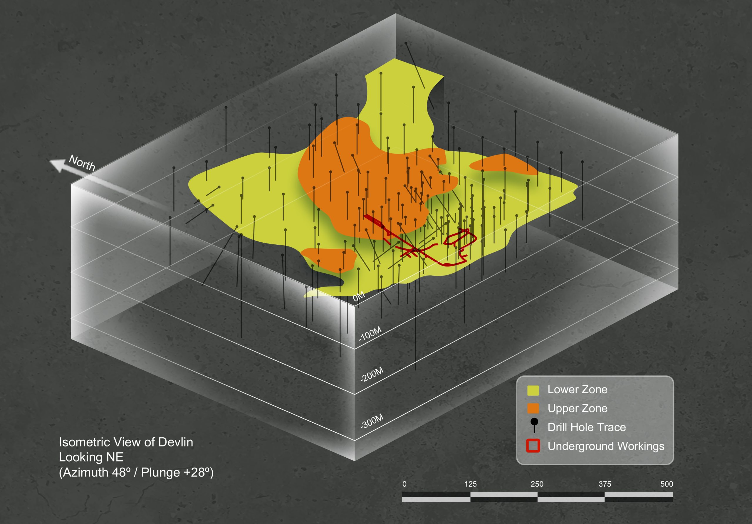
The mineral resource estimate (“MRE”) for the Devlin deposit was updated in October 2021 (see October 14, 2021 news release) based on historical drilling up to 2014. No additional drilling was completed at Devlin after 2014 except for a few metallurgical holes by Doré Copper during summer 2021. The MRE was unchanged for the PEA.
Dore Copper completed a preliminary economic assessment (“PEA”) in May 2022. The PEA contemplates the re-development plan of a hub-and-spoke operation model with Corner Bay as the main feed to the Corporation’s centralized Copper Rand mill, supplemented by the Devlin and Joe Mann deposits. The plan is to develop Devlin at the same time as Corner Bay and benefit from operational synergies.
HISTORY
From 1974 to 1978, Riocanex completed 10,023 meters of diamond drilling on the Devlin property. This drilling defined a flat lying ore body within a breccia zone, dipping 7 to 10° to the northeast at approximately 60 meters below surface.
From 1979 to 1982, Camchib Resources Inc. completed 6,269 meters of diamond drilling. In 1981, a 1,000 ft. (305 meters) access decline of 11 ft. x 15 ft. was driven at -15% to intersect the mineralization at approximately 180 ft. (55 meters) below surface. An additional 1,000 ft. (305 meters) of exploration drifting was completed along the vein confirming the continuity and grade of the copper zone. A bulk sample consisting of 2,744 short tons of development muck was processed through the Principale mill (dismantled). From an average head grade of 1.26% Cu, a copper concentrate grading 17.79% Cu was obtained with an overall copper recovery of 96.9%. In 1982, tests on 100 lb samples indicated the sample was amenable to sorting technology. A best recovery of 98.75% copper was achieved with 39% of the sorter feed being eliminated. In late 1982, Campchib completed six deeper holes totaling 2,334 meters to test the possibility of finding similar mineralized structures parallel to the main zone at greater depth (305 meters). No economic intersections were encountered. The project is then put on standby following a drop in the market value of copper and the decline is later flooded.
In 1992, Holmer Gold Mines Ltd acquired Campbell Resources Inc.’s 55% interest in the property (formerly Camchib and Campbell Chibougamau Mines Ltd.) with Riocanex retainaing the remaining 45% interest. A technical review of the project is completed in 1995.. In 2004, Lake Shore Gold acquired Holmer Gold and the Devlin property.
The Devlin property was acquired by CBay Minerals Inc. in 2013. In 2013 and 2014, CBay Minerals completed 1,749 meters of drilling in 17 holes. CBay Minerals commissioned AGP Mining Consultants Inc. to provide a mineral resource estimate and NI 43-101 Technical Report for the Devlin project. The Technical Report dated August 20, 2015 was filed on SEDAR in September 2015.
GEOLOGY & MINERALIZATION
The Devlin deposit is located in the Chibougamau Pluton in the middle of the Chibougamau anticline. The deposit is hosted by tonalite (“granodiorite”), diorite, and an extensive zone of chloritic-epidotic breccia.
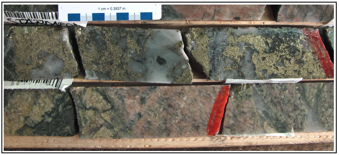
The Devlin deposit is a flat-lying (horizontal) magmatic massive sulphide deposit which is less than 100 meters from surface. The tabular ore body (or main vein) is nearly horizontal at the southern extremity and dipping slightly at 7° to the northeast at the northern extremity. The deposit is hosted by a hydrothermal breccia, though the main vein also extends out into un-brecciated banded tonalitic and dioritic rocks. It is composed of a massive chalcopyrite-pyrite-quartz +/- carbonate vein which pinches and swells. Minor hematite and magnetite are present locally, both being erratically distributed. Minor gold is present within the ore body with values typically less than 0.34 g/t. High grade intersections usually consist of one or several parallel quartz veins varying from a few centimetres to 1 meter in thickness, in which the occurrence of chalcopyrite may vary from occasional blebby specks to massive bands. Usually, a thin semi-massive to massive sulphide zone is present in the quartz vein. Chalcopyrite and pyrite also occur as fine disseminated patches and fine stringers outside of the ore zone.
Further drilling will be focused on trying to identify a sub-vertical feeder structure and identifying off-set extensions of the deposit under the lake.