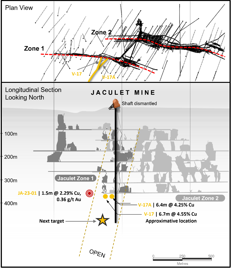
The Jaculet mine is located 2.5 kilometers by road from the Copper Rand mill and was in operation from 1960 to 1971 producing a total of 1,091,000 tonnes at 1.84% Cu, 1.44 g/t Au and 6.85 g/t Ag (20,074 tonnes of Cu and 1.57 tonnes Au)1. Jaculet was mined to a depth of 366 meters (1,200 feet) and the shaft was deepened to 500 meters (1,650 feet) in 1972.
The Jaculet mineralized system consists of two distinct subparallel shear zones separated by approximately 200 meters, known as Zone 1 and Zone 2, which both remain open at depth with very little development below 366 meters. Zone 1 extends for approximately 500 meters and has an average strike of 290° with a northerly dip ranging from 55° to near vertical. Mineralization in Zone 1 consists of chalcopyrite and minor pyrite within the sheared and altered gabbroic anorthosite. Zone 2 extends for approximately 670 meters in length and is oriented at 80° north dipping 80-85° to the south. Mineralization consists of stringers of pyrite with erratic lenses of chalcopyrite associated with siderite, sericite and chloritoid.
Doré Copper completed one drill hole of 600 meters in July 2023, which tested the strike extension of Jaculet Zone 1, approximately 100 meters to the west of a previously mined out area and near two high-grade copper intercepts in two historical holes, at a vertical depth of approximately 400 meters. The two surface historical holes, V17 and V17A (wedge from V17, located approximately 50 meters to the east), from Chibougamau Jaculet Mines Ltd. in 1956 had intersected with 4.55% Cu and 0.86 g/t Au over 6.7 meters and 4.25% Cu and 0.59 g/t Au over 6.4 meters, respectively.
Hole JA-23-01 intersected Jaculet Zone 1 with 12.29% Cu and 0.36 g/t Au over 1.5 meters, mainly chalcopyrite in centrimetric veins at a downhole depth of 438 meters. It is now interpreted that the mineralization in hole JA-23-01 is at the periphery of the main Jaculet Zone 1 ore shoot. The deposit remains open below 400 meters.
Additional drilling is planned in the near future to test the potential down plunge of Jaculet Zone 1.