Toronto, Ontario – January 22, 2024 – Doré Copper Mining Corp. (the “Company” or “Doré Copper“) (TSXV: DCMC; OTCQX: DRCMF; FRA: DCM) is pleased to announce that it has exercised its right to acquire a 65% interest in certain claims subject to a joint venture with SOQUEM (the “SOQUEM JV Property“), which surround and are adjacent to the Company’s 100% owned Joe Mann Property, pursuant to an earn-in option agreement (the “Option Agreement“) dated January 2, 2020, as amended October 28, 2022, between the Company and Ressources Jessie Inc. (“Ressources Jessie“). SOQUEM holds the remaining 35% interest in the SOQUEM JV Property.
In accordance with the terms of the Option Agreement, Ressources Jessie will transfer its 65% interest in the SOQUEM JV Property, comprising 69 claims totaling 3,029.6 ha, to the Company for $300,000 in cash and 3,333,333 common shares of the Company at a deemed price of $0.12 per common share, representing $400,000 in common shares. Following this acquisition, the Company has a controlling interest in a contiguous group of claims totaling 6,209.2 ha surrounding the former high-grade Joe Mann gold mine (Figure 1) and part of the southern Chibougamau Camp where Northern Superior Resources Inc. and IAMGOLD Corporation have significant gold mineral resources (Figure 2).
The acquisition is subject to the acceptance of the TSX Venture Exchange. The common shares issued in connection with the acquisition are subject to a four month hold period under applicable Canadian securities laws which will expire on May 23, 2024.
Ernest Mast, President and CEO of Doré Copper, commented, “With this transaction, we have consolidated a large contiguous group of claims around the former Joe Mann mine in the prolific southern Chibougamau camp. Most of the SOQUEM JV block has not been explored since the late 1990s and numerous gold targets remain to be evaluated on the property. We are looking forward to work with SOQUEM and we plan to commence a detailed review of the historical work and use new geological interpretations to generate high quality exploration targets.”
Exploration Potential on the SOQUEM JV Property
The Company’s contiguous group of claims (Figure 1) is located in the eastern part of the Abitibi Greenstone belt within the upper part of the Obatogamau Formation, within a major deformation corridor known as the Opawica-Guercheville shear zone. The Company has a 100% interest in the former Joe Mann mine, which produced 1.12 million ounces of gold at an average grade of 8.26 g/t from the 1950s to 2007.1 The deposit has an inferred mineral resource of 680,000 tonnes grading 6.78 g/t Au and 0.24% Cu, which was included in the Company’s Preliminary Economic Assessment (PEA) of its hub-and-spoke operation announced on May 10, 2022.2
The main lithologies encountered are basalts, rhyolites, gabbros and several families of felsic, intermediate and mafic dykes. Two felsic intrusions, La Dauversière and Verneuil, are found respectively to the northeast and northwest of the claim group. The stratigraphy is east-west, dipping sub-vertically, and metamorphosed to the upper greenschist facies (epidote-amphibolite facies).
A number of gold occurrences and mineralized zones have been identified on the SOQUEM JV Property and are briefly summarized below. An evaluation of all the exploration work conducted on the SOQUEM JV will be completed over the coming months to identify exploration targets. No significant exploration work on the SOQUEM JV Property has been carried out since the late 1990s, except for the Rohault and Norhart gold occurrences where the latest exploration activities took place in 2004.
Rohault
The Rohault gold occurrence is located north of the former Joe Mann mine and its western extension is located approximately 300 meters north of the mine infrastructures. This structure has been tested by drilling over a 2 kilometer strike length. The Rohault mineralized zone is characterized by quartz-carbonate veins and veinlets which cut mafic lavas and intrusions. The main occurrence contains approximately 15% pyrite and 5% chalcopyrite with several interesting historical drill intercepts: 108.71 g/t Au, 16.85 g/t Ag and 1.4% Cu over 0.6 meter at a downhole depth of 44.95 meters (H-560) and 6.32 g/t Au and 0.37% Cu over 3.6 meters (including 34.5 g/t Au and 0.99% Cu over 0.6 meter) at a downhole depth of 79.2 meters (H-518).1
Norhart
The Norhart gold occurrence is located approximately 1 kilometer north of former Joe Mann mine. The gold mineralization shows similar characteristics to Joe Mann. It is comprised of five parallel quartz vein structures, separated by between 50 and 150 meters over a strike length of approximately 500 meters. Gold mineralization is within quartz veins cutting strongly altered granular felsic dykes or basalts.
Significant historical drill intercepts in the sector of Norhart include: 65.85 g/t Au, 5.9 g/t Ag over 6.34 meters at a downhole depth of 207.46 meters (H-04-579); 160.50 g/t Au, 9.8 g/t Ag over 0.85 meters at a downhole depth of 235.0 meters (H-04-582); 81 g/t Au, 1.4 g/t Ag over 1.2 meters at a downhole depth of 234.8 meters (H-04-580); 24.65 g/t Au, 17.48 g/t Ag, 0.79% Cu over 1.92 meters at a downhole depth of 256.62 meters (H-04-578), 99.64 g/t Au, 11.8 g/t Ag and 0.12% Cu over 0.3 meter at a downhole depth of 283.85 meters (H-569); 10.04 g/t Au, 16.3 g/t Ag and 0.11% Cu over 1.2 meters at a downhole depth of 521.2 meters (H-535 EXT); 57.65 g/t Au over 0.40 meter at a downhole depth of 264.0 meters (H-550).1 ,3
Currie-Mills
The Currie Mills (Lac James) gold occurrence is located 3 kilometers east-northeast of the former Joe Mann mine. The mineralized system is parallel to Joe Mann and contains a small historical near-surface resource (not compliant with NI 43-101). Mineralization consists of two lenses (North and South) of disseminated chalcopyrite, pyrite, pyrrhotite and arsenopyrite in centimetric to decimetric quartz-carbonate veins with locally some specks of free gold with altered and sheared non-magnetic coarse gabbros. One significant historical drill hole intercept of 3.9 /t Au over 6.9 meters at a downhole depth of 61 meters (VM87-07) is located 150 meters east of the historical resource.1,4
Lac Meston
The Lac Meston gold occurrence is located 4.8 kilometers southwest of the former Joe Mann mine. The mineralization is found in a tonalite intrusion. An underground ramp of 305 meters was built in 1974 but did not access the mineralized zone. Significant historical drill hole intercepts include: 18.49 g/t Au over 3.61 meters (M-81-09), 34.21 g/t Au over 1.55 meters (A-12) and 6.92 g/t Au over 6.10 meters (A-14), all of which were at less than 100 meters depth.1,5,6
Adnor
The Adnor mineralized zone, located 3 kilometers west of Joe Mann, consists of a number of east-west subparallel veins within a sequence of pillowed massive basaltic flows injected by a variety of small felsic dykes. A significant drilling campaign was conducted in the early 1950s to define the mineralized zone. The highest drill intercept returned 2,297 g/t Au over 0.30 m (A-10). A subsequent drilling program in the early 1970s returned the following significant results: 14.40 g/t Au over 0.3 meter (N-7-2); 6.86 g/t Au over 0.6 meter (N-6); and 4.80 g/t Au over 1.5 meters (N-7). Highlight from the subsequent late 1980s drilling program include 11.04 g/t over 3.05 meters (H-380).1,7
Noranda – La Dauversière
This mineral occurrence is located approximately 3.5 kilometers east of Joe Mann. Gold mineralization is found in quartz carbonate veins with pyrrhotite-pyrite and chalcopyrite within sheared and altered gabbro. A number of diamond drill holes were completed by several companies prior to the late 1990s and significant results included: 8.16 g/t Au, 2.4 g/t Ag and 0.16% Cu over 0.55 meter (H-223); and 12.3 g/t Au over 1.02 meters (VM-89-26).1
Montgomery
This mineral showing is located approximately 2 kilometers west of Joe Mann. Gold mineralization is found in quartz veins containing varying amounts of pyrite, scheelite, chalcopyrite and local visible gold within a sheared structure covering a strike length of 475 meters and up to 8 meters wide. Significant historical intersections include: 4.41 g/t Au over 0.27 meter (M-7); 106.10 g/t Au (trench # 1 channel sample); 13.56 g/t Au (trench # 2 channel sample); and 199.66 g/t Au (trench # 4 channel sample).1
Wright Hargreaves
The mineral showing (also known as “Fancamp”) is located 500 meters southwest of the Adnor showing. Gold mineralization is erratic and associated with <1 meter quartz-carbonate+/-tourmaline veins and veinlets with auriferous pyrite in massive and pillowed basalts and co-magmatic magnetic gabbro-sills. Historical trench results include 9.88 g/t Au over 1.0 meter and 6.05 g/t Au over 1.0 meter. The only significant highlight from the latest drilling program (1980s) include 4.50 g/t over 0.60 meter (87-1).1
Lac Antoine
Located near the southwest boundary of the property, the Lac Antoine gold mineralization is associated with northeast trending quartz-carbonate veins containing up to 15% pyrite and minor chalcopyrite within pillow basalts. Historical work only reports high-grade gold assays (10 to +30 g/t Au) from grab samples.1
Bloc Sud
Located near the southwest boundary of the property, the Bloc Sud gold mineralization consists of black quartz veins (+/- sulphides) within a chlorite-sericite-ankerite schist of decametric width at the contact of a basalt-tonalite dyke. An intercept of 1.96 g/t Au over 6.25 meters, including 6.98 g/t Au over 1.35 meters (H-507), was reported from a limited drilling campaign.1
Qualified Person
Sylvain Lépine, M.Sc., P.Geo., Vice President Exploration of the Company and a “Qualified Person” within the meaning of National Instrument 43-101 – Standards of Disclosure for Mineral Projects, has reviewed and approved the scientific and technical information contained in this news release.
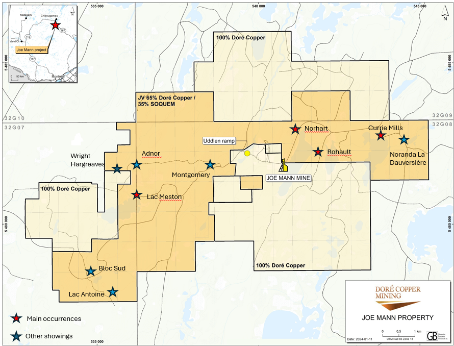
Figure 1. Joe Mann Property – Land Tenure Map and Main Gold Occurrences
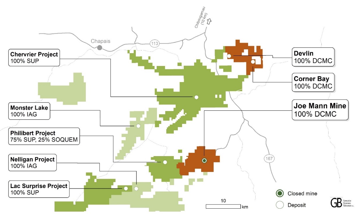
Figure 2. South Chibougamau Area – Land Tenure Map
About Doré Copper Mining Corp.
Doré Copper Mining Corp. aims to be the next copper producer in Québec with an initial production target of +50 Mlbs of copper equivalent annually by implementing a hub-and-spoke operation model with multiple high-grade copper-gold assets feeding its centralized Copper Rand mill.1 The Company has delivered its PEA in May 2022 and is proceeding with a feasibility study.
The Company has consolidated a large land package in the prolific Lac Doré/Chibougamau and Joe Mann mining camps that has historically produced 1.6 billion pounds of copper and 4.4 million ounces of gold.2 The land package includes 13 former producing mines, deposits and resource target areas within a 60-kilometre radius of the Company’s Copper Rand Mill.
For further information, please contact:
Ernest Mast
President and Chief Executive Officer
Phone: (416) 792-2229
Email:
Laurie Gaborit
VP Investor Relations
Phone: (416) 219-2049
Email:
For more information, please visit: www.dorecopper.com
Facebook: Doré Copper Mining
LinkedIn: Doré Copper Mining Corp.
Twitter: @DoreCopper
Instagram: @DoreCopperMining
- Sources for historic production figures: Economic Geology, v. 107, pp. 963–989 – Structural and Stratigraphic Controls on Magmatic, Volcanogenic, and Shear Zone-Hosted Mineralization in the Chapais-Chibougamau Mining Camp, Northeastern Abitibi, Canada by François Leclerc et al. (Lac Dore/Chibougamau mining camp) and NI 43-101 Technical Report on the Joe Mann Property dated January 11, 2016 by Geologica Groupe-Conseil Inc. for Jessie Ressources Inc. (Joe Mann mine).
- Technical report titled “Preliminary Economic Assessment for the Chibougamau Hub-and-Spoke Complex, Québec, Canada” dated June 15, 2022, in accordance with National Instrument 43-101 – Standards of Disclosure for Mineral Projects. The Technical Report was prepared by BBA Inc. with several consulting firms contributing to sections of the study, including SLR Consulting (Canada) Ltd., SRK Consulting (Canada) Inc. and WSP Inc.
- GM 62760: Ressources Meston Inc. Forage Printemps et Automne 2024, Propriete Joe Mann, Secteurs Norhart et Rohault, by Denis McNicholes, geo, dated April 8, 2005.
- GM 49329 : Cambior Inc. Rapport de la Campagne de Forages Hiver 1989, Propriété Currie-Mills by Pierre Ouelette, dated April 11, 1989.
- GM 29950: Ayarhar Mining Corp.dated December 10, 1973 by S.V. Burr (drill holes, A series).
- GM 38101: Ressources Meston Inc. Forage Hiver 1981 Meston-Gamache by Paul Gagne dated May 1981 (drill holes, M series).
- GM 49692: Drill logs. Mine Meston 1989.
Cautionary Note Regarding Forward-Looking Statements
This news release includes certain “forward-looking statements” under applicable Canadian securities legislation. Forward-looking statements include predictions, projections and forecasts and are often, but not always, identified by the use of words such as “seek”, “anticipate”, “believe”, “plan”, “estimate”, “forecast”, “expect”, “potential”, “project”, “target”, “schedule”, “budget” and “intend” and statements that an event or result “may”, “will”, “should”, “could” or “might” occur or be achieved and other similar expressions and includes the negatives thereof. All statements other than statements of historical fact included in this news release, including, without limitation, statements with respect to the timing and ability of the Company to receive necessary regulatory approvals, the Company’s ability to meet its production target, the commencement, timing and completion of a feasibility study, and the plans, operations and prospects of the Company and its properties are forward-looking statements. Forward-looking statements are necessarily based upon a number of estimates and assumptions that, while considered reasonable, are subject to known and unknown risks, uncertainties and other factors which may cause actual results and future events to differ materially from those expressed or implied by such forward-looking statements. Such factors include, but are not limited to, actual exploration results, changes in project parameters as plans continue to be refined, future metal prices, availability of capital and financing on acceptable terms, general economic, market or business conditions, uninsured risks, regulatory changes, delays or inability to receive required regulatory approvals, health emergencies, pandemics and other exploration or other risks detailed herein and from time to time in the filings made by the Company with securities regulators. Although the Company has attempted to identify important factors that could cause actual actions, events or results to differ from those described in forward-looking statements, there may be other factors that cause such actions, events or results to differ materially from those anticipated. There can be no assurance that such statements will prove to be accurate, as actual results and future events could differ materially from those anticipated in such statements. Accordingly, readers should not place undue reliance on forward-looking statements. The Company disclaims any intention or obligation to update or revise any forward-looking statements, whether as a result of new information, future events or otherwise, except as required by law.
Neither TSX Venture Exchange nor its Regulation Services Provider (as that term is defined in the policies of the TSX Venture Exchange) accepts responsibility for the adequacy or accuracy of this news release.
- 2024-07-24 Dore Copper confirms copper mineralization on its Cedar Bay Southwest Extension
- 2024-07-03 Dore Copper enters into an Agreement to acquire claims next to its flagship Corner Bay High-Grade Copper deposit
- 2024-06-20 Dore Copper announces 2024 annual and special meeting results
- 2024-04-19 Dore Copper announces grant of stock options and deferred share units
- 2024-03-27 Dore Copper identifies gold exploration potential at Norhart Zone, just North of the former Joe Mann mine
- 2024-02-26 Dore Copper announces Management changes
- 2024-01-22 Doré Copper increases size of its Joe Mann Property by acquiring a 65% interest in 3,030 hectares
- 2024-01-02 Doré Copper announces closing of rights offering
- 2023-11-21 Doré Copper announces rights offering
- 2023-10-30 Dore Copper reports excellent concentrate grades and recoveries with low impurity element concentrations from flotation tests at its Corner Bay project
- 2023-10-17 Doré Copper reports exploration drill results – intersects shallow mineralization grading 4.4 g/t Au over 9.8 metres at Gwillim
- 2023-08-01 Doré Copper provides update on its project activities
- 2023-06-06 Doré Copper announces closing of $2.8 million non-brokered private placement of common shares and flow-through shares
- 2023-05-29 Doré Copper reports High-Grade Gold mineralization at Gwillim including 9.67 g/t au over 5.3 metres